
By Johnson Siamachira
Harare, (New Ziana) — At dawn in Hwange district, in northwestern Zimbabwe, Capon Sibanda checks his mobile phone before most villagers have stirred.
Then it vibrates.
An alert warns that a herd of elephants has crossed a virtual boundary and is moving towards nearby maize fields.
Within minutes, Sibanda sends the warning through WhatsApp groups. He then unlocks his bicycle and rides from homestead to homestead, reaching families without phones or reliable network coverage.
Villagers prepare vuvuzelas and chiili bombs. They gather along the elephants’ route and drive the animals away before they reach the crops.
No trampled field. No injured villager. No retaliatory killing.
The warning begins hundreds of kilometres above the ground.
GPS collars fitted to elephants transmit their movements through satellites to EarthRanger, a wildlife-monitoring platform. When a collared elephant approaches a digitally defined boundary around a village or crop field, the system can trigger an alert, allowing community guardians and wildlife authorities to respond before conflict occurs.
For communities living alongside Zimbabwe’s wildlife, the technology represents a profound change: instead of waiting for elephants to arrive, people can sometimes know where they are going.
More importantly, the data is revealing that elephants do not recognise the boundaries humans draw on maps.
They move through national parks, forests, communal lands and safari areas as parts of one connected landscape, following water, food, seasonal resources and routes inherited over generations.
That discovery is changing how Zimbabwe thinks about sustainable wildlife conservation.
Data is redrawing the conservation map
For decades, wildlife protection largely centred on protected areas.
But GPS telemetry is exposing the limits of that approach for an animal that can travel vast distances.
“Protected areas will remain the core of conservation but these are individually mostly too small to meet all the requirements of such a large megaherbivore such as an elephant,” said wildlife ecologist and transboundary conservation planning adviser Dr. Russell Taylor.
“Large landscape conservation with human occupied space between individual protected areas is essential to meet the demands of highly mobile animals.”
Tracking data collected by the International Fund for Animal Welfare (IFAW), the Zimbabwe Parks and Wildlife Management Authority (ZimParks), and the World Wide Fund For Nature (WWF) Zimbabwe demonstrates that elephants routinely ignore administrative, district and even international boundaries.
One striking example is Samanyanga, a bull elephant fitted with a GPS collar by WWF Zimbabwe in 2023. Since then, he has travelled through Fuller Forest, Kavira Forest, communal lands and Chizarira National Park.
His journey has turned an invisible ecological connection into measurable evidence.
“The corridors provide the means whereby movement between protected areas can take place,” Dr. Taylor said.
Tinaapi Madiri, wildlife programme manager for WWF Zimbabwe, said the tracking data shows that boundaries important to people have little ecological meaning for elephants.
“Their survival depends on maintaining connectivity between different land-use types,” he said.
The lesson is simple but consequential: an elephant’s habitat does not end where a park fence, district boundary or farm begins.
Zimbabwe’s elephant dilemma
Zimbabwe is home to one of Africa’s largest savannah elephant populations. The country’s 2021–2025 Elephant Management Plan estimated about 82,000 elephants, placing Zimbabwe behind Botswana among African range states. The newer 2026–2036 plan continues to identify human-elephant conflict as a major management challenge.
Hwange National Park, Zimbabwe’s largest protected area at about 14,650 square kilometres, holds the country’s largest elephant population.
The abundance brings a difficult paradox.
Zimbabwe wants elephants to survive. Rural communities living beside them also want their crops, livestock and families to survive.
ZimParks reported that nationally,human-wildlife conflict cases increased from 1,654 in 2024 to 2,090 in 2025, a 26 per cent rise. The authority recorded 62 deaths and 81 injuries in 2025, with elephants among the species most frequently involved. It linked growing conflict partly to competition for water and grazing resources as climate change intensifies pressure on people and wildlife.
“In Zimbabwe, elephants are walking over huts and killing people in the process,” said Lungile Sibanda, director of the Communal Areas Management Programme for Indigenous resources (CAMPFIRE) and vice chairperson of the Community Leaders Network of Southern Africa.
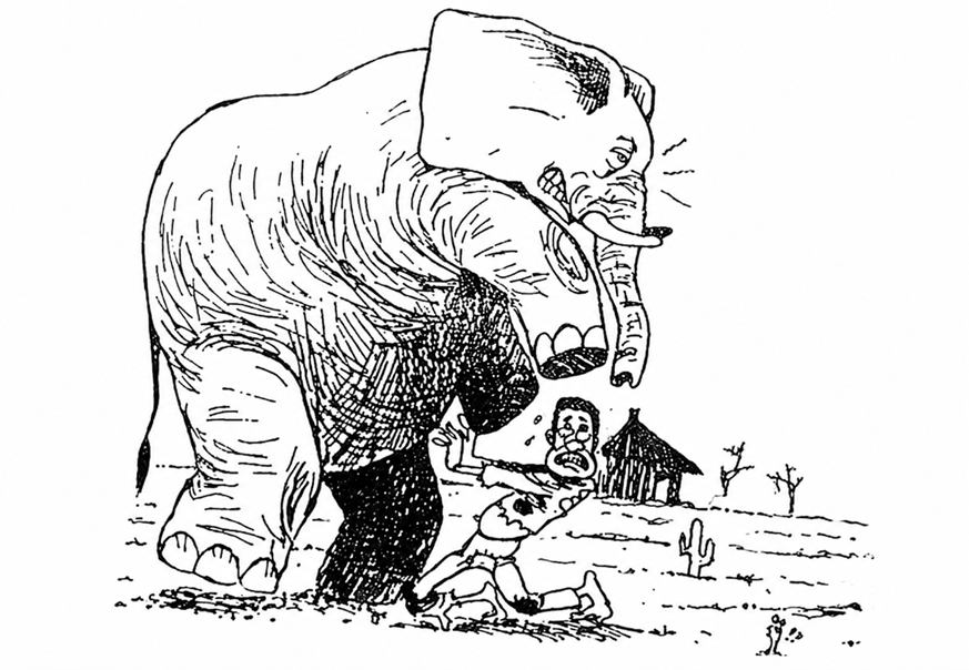
Human, wildlife conflict on the rise in Zimbabwe. Source: CAMPFIRE Association.
For farmers, an elephant herd can erase months of work in a single night.
For conservationists, every retaliatory killing removes an animal from a population already under pressure from habitat loss, poaching and other threats.
That makes early warning more than a technological experiment. It can become a practical tool for reducing conflict.
Six new collars, a bigger picture
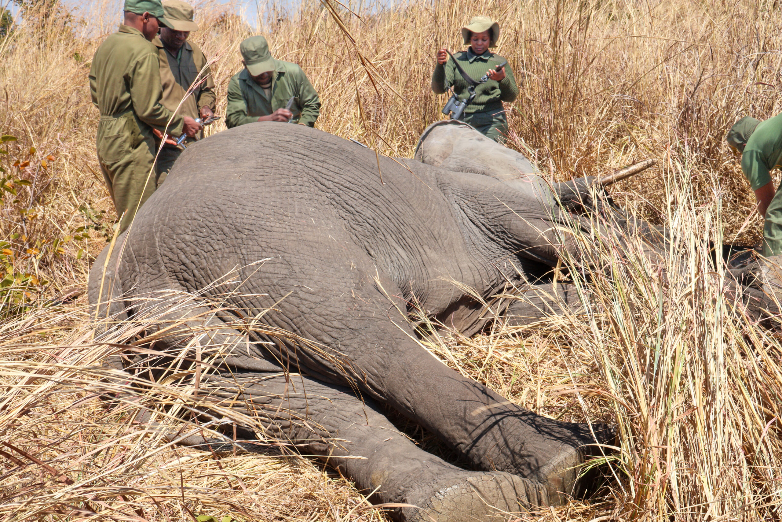
On September 9 this year, ZimParks and IFAW fitted six African savanna elephants — three females and three males — with satellite-linked collars in and around Hwange National Park.
The operation brought to 30 the number of elephants collared through the partnership since early 2024. The collars transmit location data through satellites, helping conservation teams identify movement patterns, potential conflict hotspots and wildlife corridors.
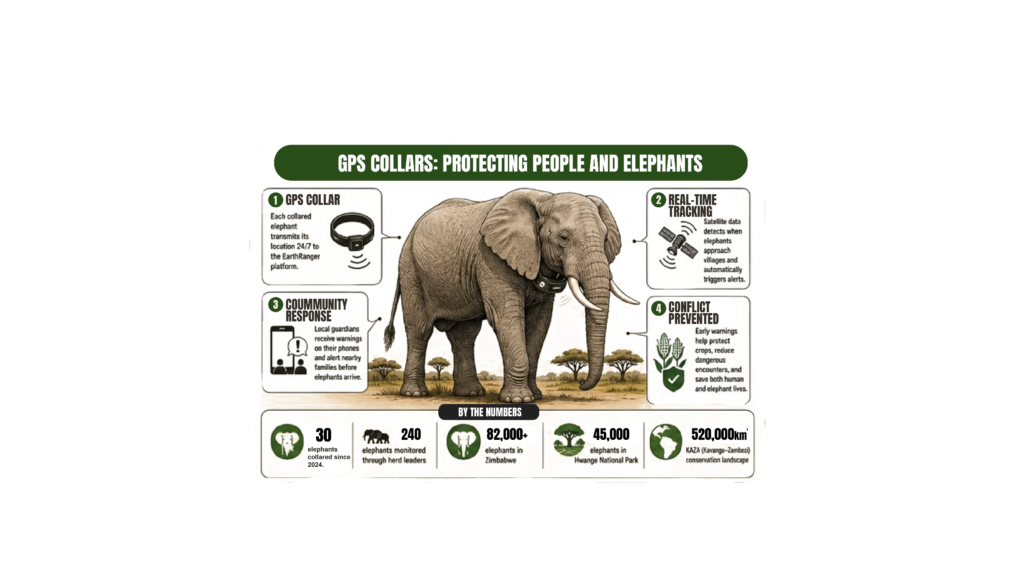
GPS collaring. Source: ZimParks
The programme builds on an earlier collaring operation in which researchers used GPS technology to study elephants moving between Hwange and surrounding human-dominated landscapes.
This collaring programme forms part of IFAW’s Room to Roam initiative, which seeks to protect, restore and reconnect about 320,000 square kilometres of elephant habitat across eastern and southern Africa. Data from the Hwange landscape will help identify corridors and dispersal areas that are important for maintaining connected wildlife populations.
“’The work demonstrates how science and technology can strengthen conservation efforts,” said Phillip Kuvawoga, IFAW senior director for the Landscape Conservation Programme.
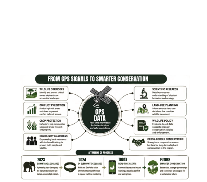
GPS technology transforming conservation. Source: International Fund for Animal Welfare.
The technology can turn an approaching herd into a warning rather than a surprise.
Professor Edson Gandiwa, ZimParks director general, said scientific evidence would strengthen elephant management and efforts to promote coexistence between people and wildlife. “Through our partnership with IFAW, this programme is generating valuable information to strengthen elephant management and support coexistence between people and wildlife,” adding: “Conservation decisions are strongest when guided by sound scientific evidence.’’
Alleta Nyahuye, IFAW Zimbabwe country director, described the strongest evidence of the system’s value as the incidents that never happen.
Those “non-events” rarely make headlines.
A field that survives does not generate a news story.
A family that never encounters an elephant does not appear in a casualty statistic.
Yet for a farmer, an uneventful night can mean the difference between a harvest and hunger.
Following water in a hotter landscape
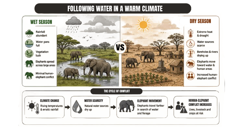
As natural pans disappear, herds move closer to villages searching for water and forage. Source: Journalist Johnson Siamachira Own Creation.
With frequent droughts in the region, the collars are also helping scientists examine how elephants respond to changing environmental conditions.
During prolonged dry periods, natural water sources can disappear, pushing wildlife towards permanent rivers, artificial water points and human settlements.
ZimParks has linked the recent rise in human-wildlife conflict partly to climate-driven competition for scarce water and grazing.
‘’Elephants destroy our crops as they search for food, worsening our already food insecurity challenge,’’says Senzeni Sibanda, a local farmer and councillor in Hwange. ‘’But with the Earth Ranger system, we’re poised to reap abundant harvests as marauding elephants will be kept at bay.’’
In Hwange, another major change is unfolding.
The Gwayi-Shangani Dam, under construction less than 50 kilometres from the park, could alter how elephants use the surrounding landscape. Conservationists began collaring elephants partly to establish a baseline for understanding those changes.
The reservoir could create new water availability and potentially influence elephant movements. Tracking data will help scientists compare elephant behaviour before and after the landscape changes.
It is a reminder that conservation maps cannot remain static while the climate, water systems and human footprint change around them.
Technology meets tradition
But satellites cannot protect elephants on their own.
People do.
Community guardians such as Capon Sibanda receive alerts, verify elephant movements and coordinate responses with rangers and neighbours.
The approach builds on a much older lesson from Zimbabwe’s CAMPFIRE programme, which links wildlife management with rural development.
CAMPFIRE currently operates in 58 districts, affects about 2.4 million people and supports community management of about 50,000 square kilometres of habitat.
Its central lesson remains relevant: conservation becomes more sustainable when communities have a meaningful role in managing wildlife and receive tangible benefits from it.
GPS technology adds another potential benefit — information.
Knowing that elephants are approaching gives communities time to act.
A warning can be as valuable as compensation after a crop has already been destroyed.
Conservation without borders
The implications extend far beyond Hwange.
The park forms part of the Kavango-Zambezi Transfrontier Conservation Area, a vast conservation landscape spanning Angola, Botswana, Namibia, Zambia and Zimbabwe.
Elephants do not need passports to cross it.
Tracking has already documented movements between forests and protected areas in northwestern Zimbabwe and into neighbouring Botswana, reinforcing the importance of conservation planning across political boundaries.
This is where the invisible highways become visible.
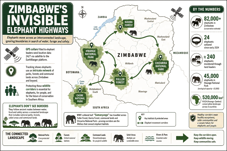
Above: Zimbabwe’s invisible elephant highways. Source: International Fund for Animal Welfare.
Each GPS coordinate adds another point to a growing map.
Each point helps reveal where elephants feed, drink, rest, breed and move.
Together, the points can expose corridors that may otherwise look like ordinary woodland, farmland or communal land on a conventional map.
Those corridors can then inform land-use planning, early-warning systems and efforts to reduce conflict.
Some observers believe that a new conservation approach is slowly emerging from such technology-based initiatives, in which people rediscover ways to live in harmony with nature, rather than be entirely separated from it.
The future lies between the parks
For much of modern conservation history, success often meant counting animals and protecting the places where they lived.
Satellite tracking is adding another question: Where do they go?
The answer is increasingly clear.
Elephants need parks — but they also need the landscapes between them.
They need forests, rivers, communal areas, seasonal feeding grounds and safe routes connecting one habitat to another.
The challenge for Zimbabwe is therefore not simply to protect elephants inside Hwange National Park.
It is to understand and manage the invisible highways that carry them beyond its boundaries.
Back in Hwange, Capon Sibanda’s phone vibrates again.
Another alert.
Another herd has changed direction before reaching the village.
There is no destroyed maize field.
No injured farmer.
No retaliatory killing.
Families who never encounter elephants rarely make headlines on news platforms.
But somewhere inside a growing stream of satellite coordinates, another small success has been recorded.
The future of elephant conservation may depend not only on the parks Zimbabwe protects, but on the invisible roads elephants use to move between them.
‘’Although we have too many elephants in our area, the EarthRanger platform is helping us harvest ‘something’ from our field crops. We now have renewed hope in smallholder agricultural production, ‘’ says Capon Sibanda.